Tag: Southern California weather

  • National Weather Service Says Tropical Storm Battering Southern California Is the “least likely outcome” for Weekend Forecast

    National Weather Service Says Tropical Storm Battering Southern California Is the “least likely outcome” for Weekend Forecast

    Southern California Tropical Storm Threat Remains Unlikely, Forecasters Say

    Forecasters say the likelihood of a tropical storm or hurricane making landfall in Southern California in the coming days remains low, despite uncertainty surrounding what the National Weather Service called a challenging Labor Day weekend forecast.

    Concerns have grown after some weather models suggested that a tropical storm could form off the coast of Mexico this week and bring strong winds and rain to Southern California. However, forecasters are reassuring residents that the chances of damage-inducing weather remain small.

    The main message is that while significant winds and rain associated with a tropical storm is possible, it is the least likely outcome at this point, the NWS said in a bulletin.

    Weather models show significant uncertainty

    CBS LA meteorologists said current models show the potential storm is still about six days away, leaving considerable room for changes in its track and strength.

    Only a minority of models are actually showing a tropical system reaching Southern California, said CBS LA Weather Producer Patrick Wright. There’s a lot that goes into a tropical storm, or system in general, making it to Southern California … Everything must go perfectly correct for that to happen.

    Models show tropical developments in the Pacific Ocean.

    The systems developing in the Pacific Ocean this week appear likely to be massive, Wright said. Even small changes in their behavior could significantly affect their projected paths and intensity.

    A perfect sequence of events that we’re not very confident in would have to occur for a tropical system to strengthen and travel north toward Southern California, Wright said.

    Current forecasts point to high humidity and only slight chances of rain showers. We could see absolutely nothing, he said. Or, some minority models show something, which these details can be ironed out over the next couple of days.

  • Is a Hurricane Coming to Southern California This Weekend? Experts Say It’s Unlikely

    Is a Hurricane Coming to Southern California This Weekend? Experts Say It’s Unlikely

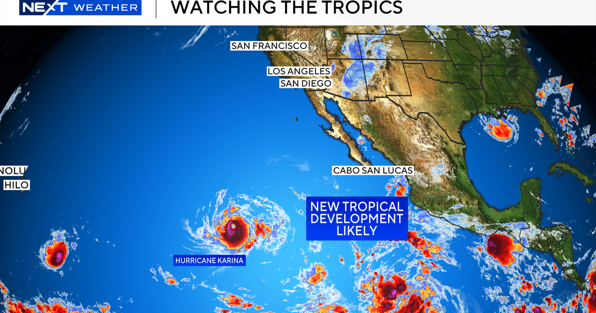
    A tropical disturbance developing near the southern tip of Baja California could bring rainfall and elevated surf to Southern California this weekend, but forecasters say it is too early to predict the system’s impact.

    The National Weather Service said a reliable forecast will not be possible until the disturbance develops into a tropical storm and begins moving.

    “It’s very much in the air at this point, other than the elevated surf,” said Lauren Villafane, a National Weather Service meteorologist. “That’s the only thing we can say with any kind of certainty.”

    If the storm remains near the coast, Southern California could face a 20% chance of rain over the weekend, along with increased swells along the coastline, meteorologists said.

    Storm’s path will determine Southern California impacts

    If the system moves west, similar to Hurricane Karina over the weekend, its effects would likely be limited to sustained high humidity and elevated surf.

    “This happens every year,” said Mike Wofford, another National Weather Service meteorologist. “Off Mexico, they form, they move on the ocean and they go in different directions depending on what the upper pattern is.

    “Most of these systems tend to weaken considerably before they get here,” he added.

    The cautious forecast issued Monday contrasted with online and social media speculation over the weekend that a hurricane could reach Southern California. Some posts even referred to the potential storm as Hurricane Marie.

    The disturbance is developing as Southern California receives a break from a prolonged heat wave that brought higher-than-normal humidity.

    Villafane said the cold water off the California coast “really does kill a lot of storms, so we don’t have to worry about it being a hurricane by the time it gets up here, if it does at all.”

    Southern California’s most recent tropical storm

    The last tropical storm to reach Southern California was in August 2023, when Hurricane Hilary traveled along the West Coast. However, it weakened before making landfall.

    Even so, the storm produced record rainfall, including about 8.5 inches on Mt. Wilson. Most valley areas received between 2 and 4 inches.

    Forecasters said it remains too soon to determine how the current tropical disturbance could affect Southern California.

    “We have to see what happens in terms of the direction it takes and whether it crosses the (U.S.-Mexico) border or not, and then how much … rain develops,” Wofford said. “There’s a lot of unknowns. The storm hasn’t even formed yet.”

  • Tropical Storm Marie Could Become a Hurricane, Bringing Rain and High Surf to Southern California on Labor Day

    Tropical Storm Marie Could Become a Hurricane, Bringing Rain and High Surf to Southern California on Labor Day

    El Niño’s warm Pacific waters could influence Southern California weather over Labor Day weekend as Tropical Storm Marie moves north and may strengthen into a hurricane.

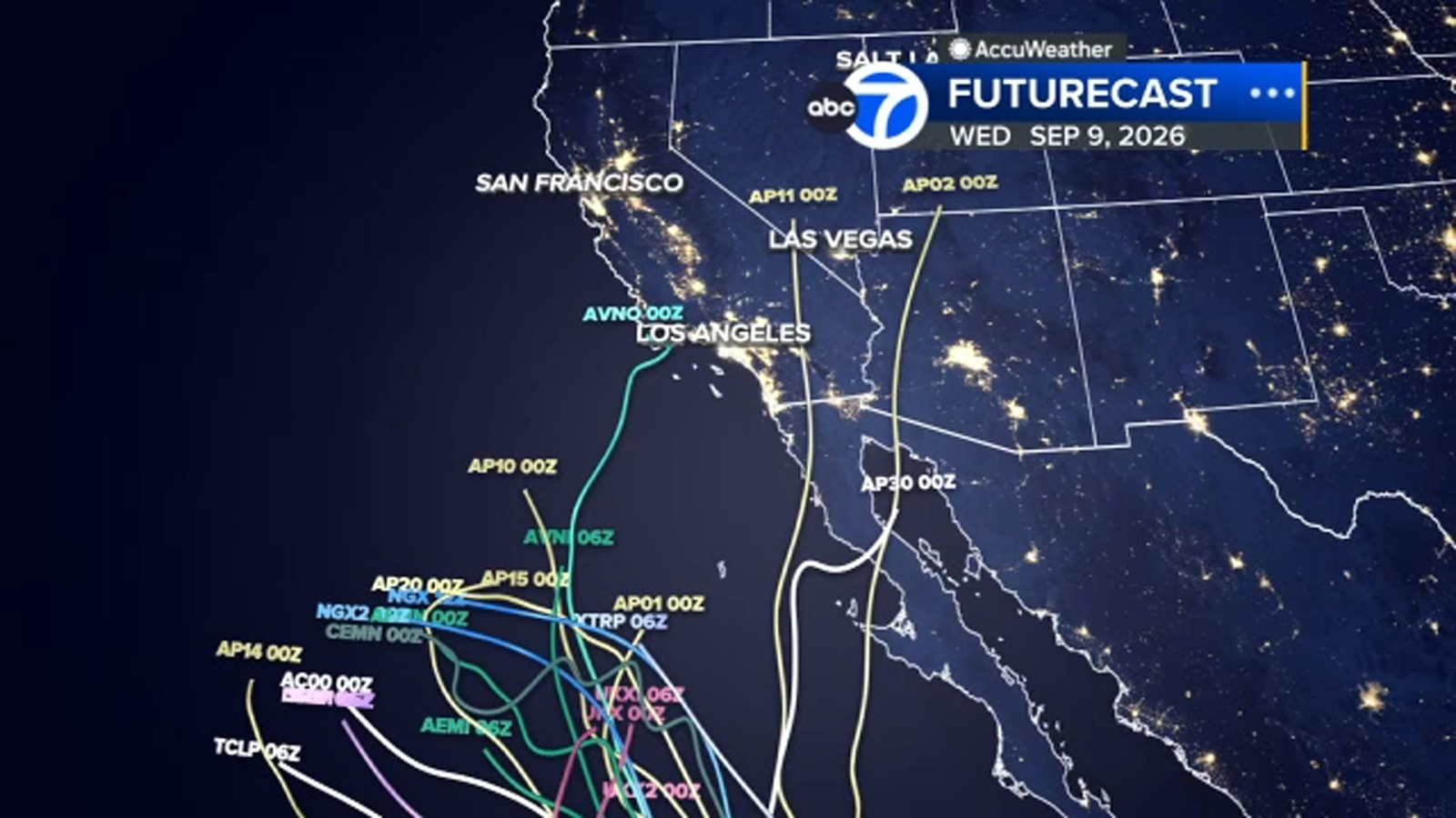
    Several computer models show Marie approaching the Southern California coast, although forecasts remain uncertain. Some spaghetti models place the storm closer to the region than others, but the majority keep it away from the coast.

    Tropical Storm Marie could bring rain, wind and high surf

    Current forecasts show Marie over the Pacific Ocean, with some models indicating that it could strengthen into a hurricane by the weekend. If the storm moves near Southern California, it could bring rain, gusty winds and high surf during the Labor Day holiday.

    On Tuesday, the National Weather Service said there is a high chance of large waves and strong rip currents for people visiting Southern California beaches. Experts also see a moderate chance of impactful coastal flooding along south-facing shores.

    The NWS said there is a moderate chance of light rain affecting holiday events, along with a low chance of moderate to heavy rain, flooding and thunderstorms.

    Regardless of Marie’s exact path, forecasters expect the storm to be strong enough to increase surf and rip currents over Labor Day weekend because of the large swell generated by tropical activity.

    What are spaghetti models?

    These forecast maps are called spaghetti models because their many lines resemble a plate of spaghetti. The lines are produced by some of the world’s fastest computers, which perform billions of calculations to estimate where a tropical system, such as a hurricane, could move.

    When the lines cluster together, forecasters have greater confidence in the projected track. Lines spread far apart indicate more uncertainty.

    Are all spaghetti models the same?

    No. Spaghetti models include several types of forecasting systems, including dynamical, statistical and ensemble models.

    Dynamical models use supercomputers to solve physical equations of motion and produce forecasts. Statistical models rely on historical relationships between storm behavior and details specific to the storm, such as its location and the date.

    Ensemble, or consensus models, combine forecasts from a collection of other models. All models show a storm’s expected track, and many also estimate how strong the storm could become.

    Who makes spaghetti models?

    Governments and private companies around the world operate weather models. Some are publicly available, while others are private. The model’s name often identifies the organization responsible for it.

    For example, the “Navy Global Environmental Model” is operated by the United States Navy’s Fleet Numerical Meteorology and Oceanography Center.

    Other familiar systems include the American (GFS) and European (ECMWF) models, which are run by the U.S. government and a partnership of European countries, respectively.

    Various companies combine the forecasts and display them on a single map. CNN, for example, uses a software company to plot the latest models on the CNN Storm Tracker when monitoring active storms.

    When should you check spaghetti models?

    The simple answer is frequently. Weather models run multiple times a day and can change quickly.

    The most important factor is to watch for trends. Check whether the models are shifting north or south, or whether most of them indicate that the storm is moving faster.

    Consistency is also important. If the plots are moving north, for example, check whether they have continued shifting in that direction during the past three model updates.

    No forecast is perfect, but spaghetti models help show where powerful tropical systems may go. That information can help communities prepare for a potential hurricane.

    CNN Wire contributed to this report.

    Copyright © 2026 KABC Television, LLC. All rights reserved.

  • Marie Won’t Hit California, but Some Impacts Are Possible

    Marie Won’t Hit California, but Some Impacts Are Possible

    Hurricane Marie is unlikely to reach California, but the storm could still affect the region over the holiday weekend. Possible impacts include high surf, coastal flooding, rip currents, and perhaps showers and thunderstorms across the Los Angeles Basin.

    Where Hurricane Marie is now

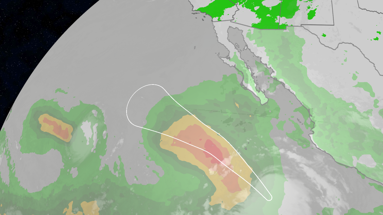
    Marie is currently well off Mexico’s Pacific coast. The National Hurricane Center’s latest forecast shows the storm’s location, status, and five-day forecast cone.

    (MORE: What the forecast cone means)

    Where Hurricane Marie could go

    Forecast models have offered two different scenarios for Marie’s path in recent days.

    One group of models shows Marie continuing west-northwest this weekend and into next week, keeping the storm far from land. Another group turns Marie toward the north, bringing what remains of the storm close to—or possibly over—parts of Southern California early next week.

    While it is too soon to rule out either scenario, the more likely outcome is that Marie remains far from land.

    Even if Marie moves farther north, dry and stable air combined with the cooler, although still much warmer than usual, waters of the California ocean current would likely weaken the storm significantly. A similar process occurred in August 2023 with what was once Hurricane Hilary.

    Because of these conditions, tropical cyclones are rare near Southern California. The only known Southern California hurricane struck San Diego before the Civil War.

    Possible impacts in California

    California could still experience weather effects from Marie and the broader atmospheric pattern, even if the storm stays hundreds of miles offshore.

    High surf, rip currents and coastal flooding

    Swells generated by Marie are expected to move toward the Southern California coast this weekend, according to the National Weather Service. Large breaking waves and dangerous rip currents could result even if Marie remains far offshore.

    The National Weather Service also warned of possible coastal flooding, particularly along south-facing shores.

    Showers and thunderstorms

    Showers and thunderstorms are expected to increase across much of the West, including parts of California, from later this week through early next week.

    A southward plunge of the jet stream into the West Coast will draw additional tropical moisture into the region, including some moisture associated with Marie. Storms could produce locally heavy, flooding rainfall, especially in hilly, mountainous, urban, and desert areas.

    What residents should do

    People in California and the Desert Southwest should continue monitoring the forecast for Marie in case the storm’s projected path changes.

    Residents and visitors should also:

    • Stay out of the ocean unless you are an experienced surfer or strong swimmer. If you enter the water, stay near lifeguards.
    • Know whether you live near areas recently burned by wildfires.
    • Keep a go-bag ready in case flash flooding or debris flows lead to evacuations.
    • Never drive through flooded roads or around barricades. Turn around and find an alternate route.
    • Consider postponing hikes and outdoor activities in canyons or mountainous areas when thunderstorms are forecast.

    Thunderstorms several miles away can trigger dangerous, fast-moving flash floods that sweep through canyons with little warning.

    Jonathan Erdman is a senior meteorologist at weather.com who has covered national and international weather since 1996. Extreme and bizarre weather are his favorite topics. Reach out to him on Bluesky, X (formerly Twitter) and Facebook.