Tag: Hurricane Karina

  • Pacific Hurricanes Active, Atlantic Season Still Without Storms This Year

    Pacific Hurricanes Active, Atlantic Season Still Without Storms This Year

    Three Simultaneous Pacific Hurricanes Contrast with Quiet Atlantic Season

    An unusual meteorological pattern has emerged across the Pacific and Atlantic basins. Three hurricanes are currently active in the Pacific Ocean, while the Atlantic remains hurricane-free well into September—a rare occurrence in the satellite era.

    Pacific Basin Sees Three Active Hurricanes

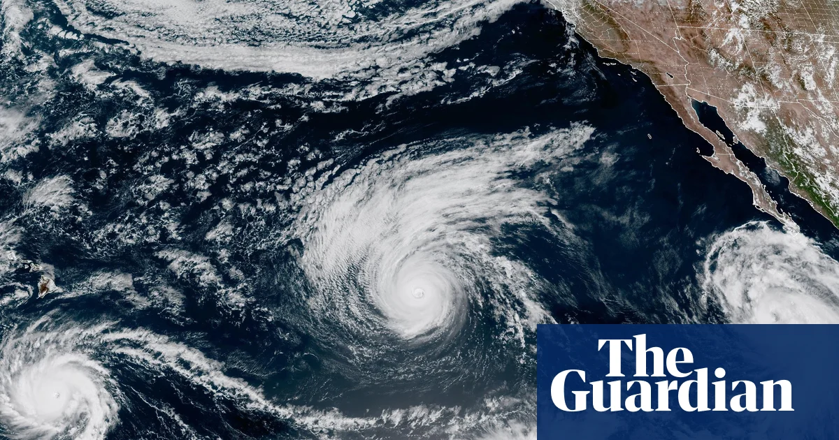
    Category 1 Hurricane Marie, Category 3 Hurricane Karina, and Category 4 Hurricane Lowell are all spinning in the Pacific simultaneously. According to the National Hurricane Center (NHC), having three hurricanes at once is highly unusual; the annual average is only eight Pacific hurricanes total. This phenomenon last occurred in 2015, when three Category 4 hurricanes existed concurrently.

    The NHC notes significant uncertainty regarding Hurricane Lowell’s potential track, making it too early to determine any impacts on Hawaii. Meanwhile, Hurricanes Marie and Karina are expected to remain over open waters with no current threat to land.

    Atlantic Hurricane Season Remains Historically Quiet

    In stark contrast, the Atlantic basin has not produced a single hurricane so far this season. This marks only the eighth year since satellite monitoring began around 1960 that the Atlantic has entered September without a hurricane formation. Forecast models indicate continued quiet conditions for at least the next seven days.

    This lull creates a possibility of breaking the record for the latest first Atlantic hurricane formation, currently held by September 11 in both 2002 and 2013.

    Tropical Storm Edouard Impacts Gulf Coast

    While the Atlantic lacks hurricanes, Tropical Storm Edouard made landfall in Louisiana at 11:25 UTC (12:25 BST) on September 1. The storm brought strong wind gusts, heavy rainfall, and flooding primarily to southwestern Louisiana and southeastern Texas. The highest recorded wind gust reached 69 mph at the Beaumont/Port Arthur airport.

    Impacts included widespread power outages and school closures. Flash flooding remains a continuing risk across east-central Texas throughout the week.

    Extreme Heat Grips Southern Texas

    Separate from tropical weather, parts of Texas are under an extreme heat warning. Heat index values—which measure how hot conditions feel when humidity combines with air temperature—have reached 46°C (114.8°F) at the state’s southern tip. The National Weather Service has identified heat-related illnesses as the primary health concern.

    Europe Records Warmest Summer on Record

    Across the Atlantic, Europe has just concluded its warmest summer since records began. The United Kingdom, France, and Belgium have all shattered mean temperature records by significant margins. France exceeded its previous 2003 record by 0.8°C, while the UK surpassed its 2025 record by 0.4°C. Additional national records are expected as more data becomes available.

  • Is a Hurricane Coming to Southern California This Weekend? Experts Say It’s Unlikely

    Is a Hurricane Coming to Southern California This Weekend? Experts Say It’s Unlikely

    A tropical disturbance developing near the southern tip of Baja California could bring rainfall and elevated surf to Southern California this weekend, but forecasters say it is too early to predict the system’s impact.

    The National Weather Service said a reliable forecast will not be possible until the disturbance develops into a tropical storm and begins moving.

    “It’s very much in the air at this point, other than the elevated surf,” said Lauren Villafane, a National Weather Service meteorologist. “That’s the only thing we can say with any kind of certainty.”

    If the storm remains near the coast, Southern California could face a 20% chance of rain over the weekend, along with increased swells along the coastline, meteorologists said.

    Storm’s path will determine Southern California impacts

    If the system moves west, similar to Hurricane Karina over the weekend, its effects would likely be limited to sustained high humidity and elevated surf.

    “This happens every year,” said Mike Wofford, another National Weather Service meteorologist. “Off Mexico, they form, they move on the ocean and they go in different directions depending on what the upper pattern is.

    “Most of these systems tend to weaken considerably before they get here,” he added.

    The cautious forecast issued Monday contrasted with online and social media speculation over the weekend that a hurricane could reach Southern California. Some posts even referred to the potential storm as Hurricane Marie.

    The disturbance is developing as Southern California receives a break from a prolonged heat wave that brought higher-than-normal humidity.

    Villafane said the cold water off the California coast “really does kill a lot of storms, so we don’t have to worry about it being a hurricane by the time it gets up here, if it does at all.”

    Southern California’s most recent tropical storm

    The last tropical storm to reach Southern California was in August 2023, when Hurricane Hilary traveled along the West Coast. However, it weakened before making landfall.

    Even so, the storm produced record rainfall, including about 8.5 inches on Mt. Wilson. Most valley areas received between 2 and 4 inches.

    Forecasters said it remains too soon to determine how the current tropical disturbance could affect Southern California.

    “We have to see what happens in terms of the direction it takes and whether it crosses the (U.S.-Mexico) border or not, and then how much … rain develops,” Wofford said. “There’s a lot of unknowns. The storm hasn’t even formed yet.”