Tag: Coastal flooding

  • Nor’easter Slams East Coast With Flooding, Dramatic Videos Show

    Nor’easter Slams East Coast With Flooding, Dramatic Videos Show

    Key Highlights

    • A nor’easter is battering the East Coast with heavy wind and rain, with forecasters warning the worst conditions are still ahead.
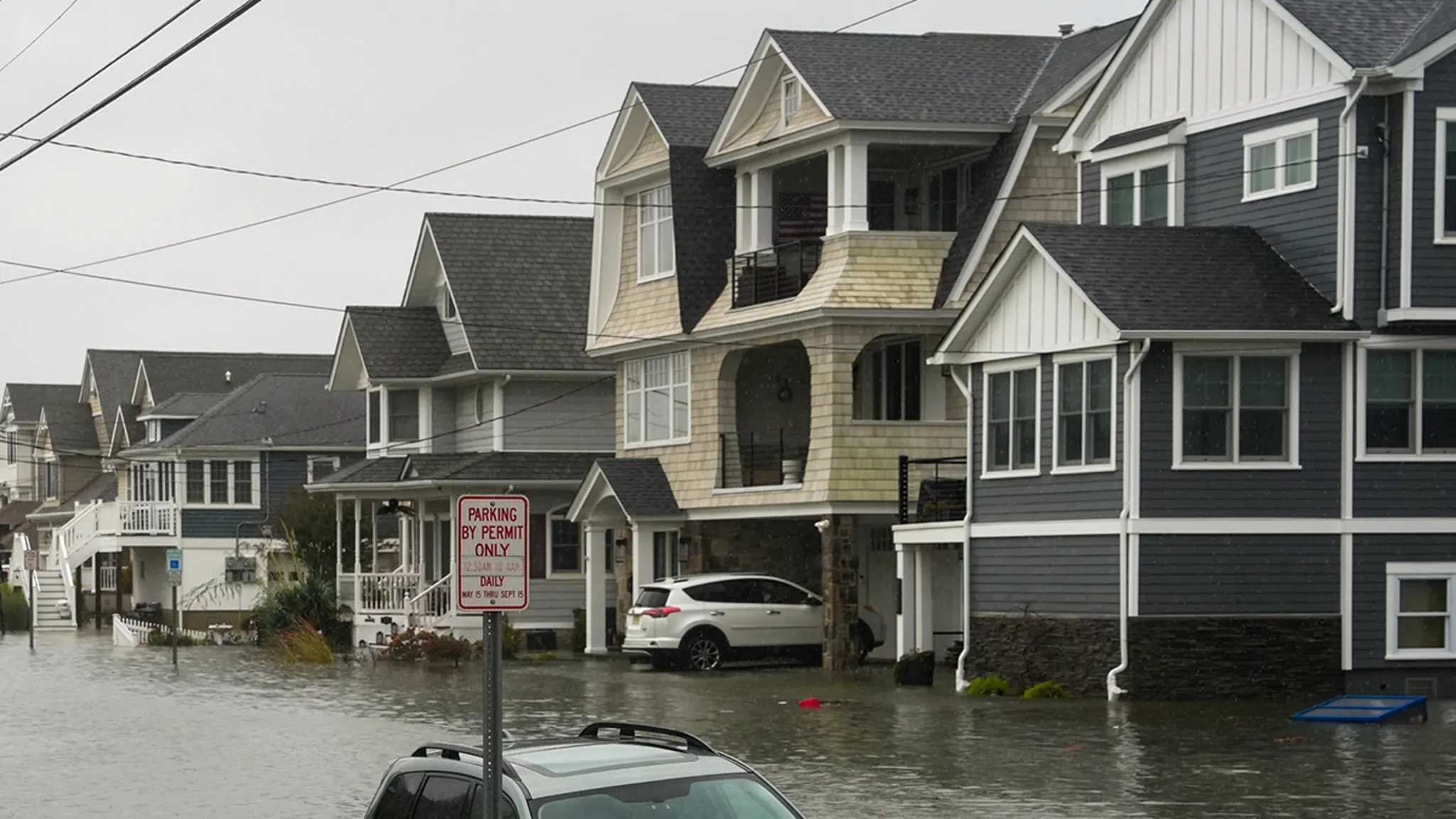
    • Photos and video footage document devastating coastal flooding, particularly along the Jersey Shore.
    • The storm system continues to intensify, prompting emergency preparations across multiple states.

    Nor’easter Slams East Coast as Flooding Escalates

    A powerful nor’easter system has been pummeling the East Coast with heavy wind and rain, unleashing dangerous conditions that meteorologists say will worsen in the coming hours. The storm has already generated devastating coastal flooding, with the Jersey Shore emerging as one of the hardest-hit regions. Visual documentation circulating overnight captures the rapid escalation of floodwaters inundating shoreline communities.

    Jersey Shore Bears Brunt of Initial Impact

    Among the hardest-hit areas is the Jersey Shore, where video taken last night reveals the destructive force of storm surge combining with astronomical high tides. The footage shows seawater breaching dunes, overwhelming bulkheads, and flooding roadways in communities accustomed to coastal storms but unprepared for the speed and volume of this event. Emergency management officials along the New Jersey coastline have activated response protocols as reports of stranded vehicles and structural damage increase.

    Forecasters Warn Peak Intensity Still Ahead

    Even though significant flooding has already occurred, meteorological projections indicate the worst is yet to come. The nor’easter continues to deepen as it tracks northeastward, drawing abundant Atlantic moisture into a tightening pressure gradient. This configuration will sustain prolonged periods of onshore flow, stacking successive high tide cycles with increasing wave action and rainfall totals. The extended duration of the event—spanning multiple tidal cycles—amplifies the cumulative flood threat beyond what a single surge event would produce.

    Why This Matters

    Nor’easters represent one of the most disruptive weather hazards for the densely populated Northeast corridor. Unlike tropical systems that typically accelerate through the region, these extratropical cyclones often stall or move slowly, subjecting coastal and inland areas to prolonged battering. The combination of storm surge, freshwater flooding from heavy rainfall, and high winds creates compound hazards that strain infrastructure, overwhelm drainage systems, and complicate evacuation and rescue operations. With sea levels rising along the Mid-Atlantic coast, the baseline for coastal flooding has shifted upward, meaning storms of this magnitude now produce impacts that would have required stronger systems in previous decades. Emergency managers emphasize that the multi-day duration of this event requires sustained public vigilance rather than a single preparation window.

    Frequently Asked Questions

    What areas face the greatest threat from this nor’easter?

    The Jersey Shore has been identified as among the hardest-hit regions so far, but the entire East Coast from the Mid-Atlantic through New England faces significant coastal flooding, heavy rainfall, and damaging winds as the system progresses.

    How long will the storm’s impacts last?

    Forecasters indicate the worst conditions are still ahead, with the nor’easter expected to affect the region through multiple tidal cycles. The prolonged duration—spanning several days—means flooding threats will persist across successive high tides.

    What makes this nor’easter particularly dangerous?

    The combination of heavy rain, sustained onshore winds, storm surge, and the storm’s slow movement creates compound flooding hazards. The system’s duration across multiple high tide cycles amplifies coastal flood risks beyond a typical single-cycle event.
  • Kelvin Waves Headed for California Coast This Fall

    Kelvin Waves Headed for California Coast This Fall

    A coastally trapped Kelvin wave is advancing northward along the Mexican coastline and is projected to reach California waters over the coming month, bringing elevated sea levels, record-warm ocean temperatures, and increased coastal flooding risks.

    What Is a Coastally Trapped Kelvin Wave?

    If the term “Kelvin wave” is unfamiliar, you are not alone. These waves are a feature of fluid dynamics that rarely affect daily life. However, the phenomenon currently moving up the West Coast is a direct manifestation of the strengthening El Niño pattern and will become increasingly relevant to California residents in the weeks ahead.

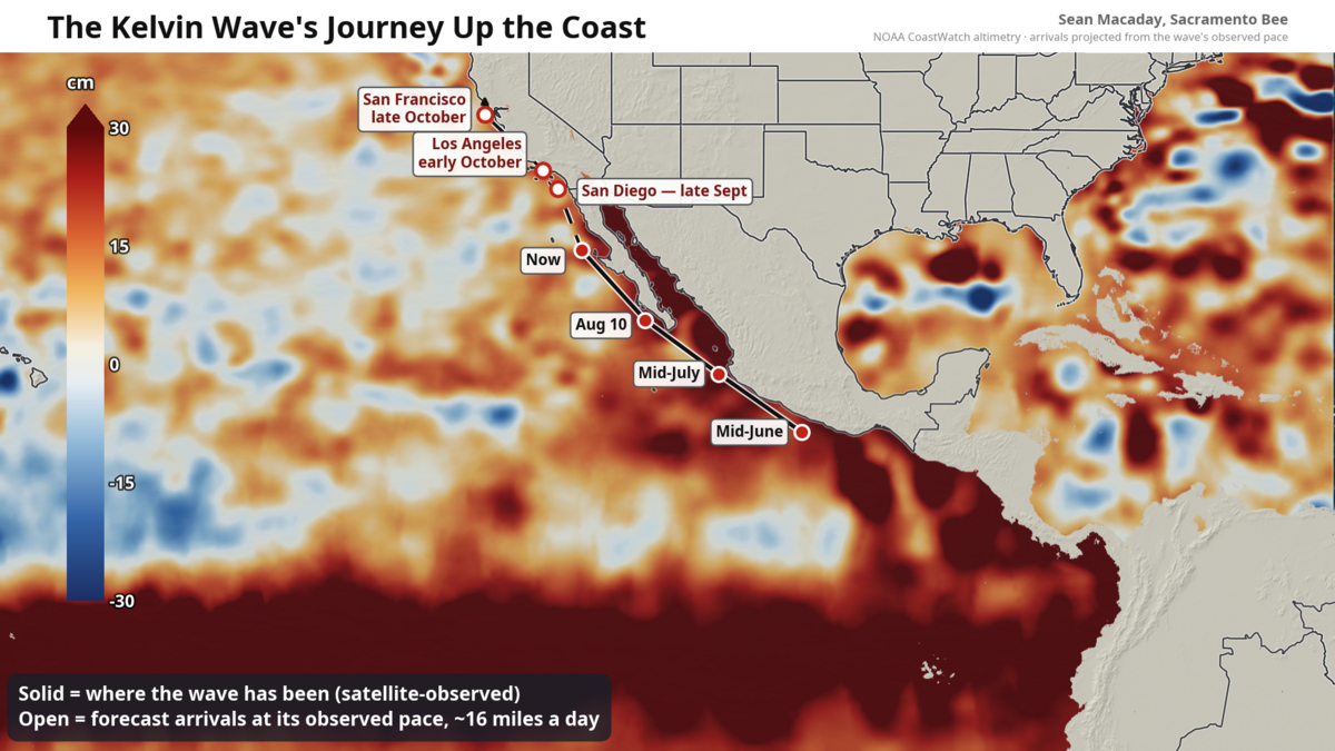
    Scientifically classified as a coastally trapped wave, this pulse of warm, elevated ocean water stretches hundreds of miles and is traveling north at roughly 6 mph — approximately the pace of a jogger. As of this week, the wave’s leading edge sits about 300 miles south of Southern California’s beaches, centered off central Baja California.

    Origins in the Western Pacific

    The wave originated months ago in the far western Pacific, where bursts of westerly wind along the equator shoved a massive pulse of warm water eastward across the ocean basin. When that pulse encountered Central America early this summer, the Earth’s rotation and the coastline’s geometry forced a portion of it to turn left and hug the shore northward, trapped against the coast by the Coriolis effect and the deep pool of warm water accumulated by El Niño.

    This is a “downwelling” Kelvin wave: the original warm pulse is so thick that it pushes the thermocline deeper, suppressing the normal upwelling of cold, nutrient-rich water that typically keeps the eastern Pacific cool. Satellite altimetry has tracked its progress continuously — passing Acapulco in mid-June, Puerto Vallarta in mid-July, and the tip of the Baja Peninsula in early August.

    Current Conditions and Projected Arrival

    Inside the wave, sea levels are running 4 to 8 inches above normal, and water temperatures off Baja have been measured in the mid-80s Fahrenheit. At its current speed, the wave is expected to reach:

    • San Diego by late September
    • Los Angeles shortly thereafter
    • San Francisco around mid- to late October

    Coastal Flooding: A Game of Margins

    A few inches of additional sea level may sound minor, but coastal flooding operates on margins stacked upon margins. This is not a tsunami; there will be no sudden impact. Instead, the wave quietly raises the baseline upon which daily tides ride for weeks or months.

    The effect is most pronounced during peak high tides — typically around full and new moons. With the baseline already elevated, water that would normally stop at the top of the beach can inundate parking lots, bike paths, and low-lying streets. The National Weather Service is expected to issue coastal flood advisories around high-tide windows once the wave settles in. Additionally, any incoming swell will produce larger wave run-up and accelerated beach erosion.

    Impacts Extend Inland to the Sacramento–San Joaquin Delta

    The connection reaches farther inland than a map suggests. The Delta is tidal, and in early fall — when river flows are near their annual low — the ocean’s twice-daily pulse propagates all the way up the Sacramento River to downtown Sacramento. A higher ocean at the Golden Gate translates into a smaller but measurable lift in water levels through the Delta’s leveed margins upstream. This also shifts the delicate balance between river outflow and salty bay water pushing inland, a critical factor for water quality and ecosystem health.

    Record-Breaking Ocean Temperatures and Marine Heatwave

    Coastal ocean temperatures will warm rapidly as the wave arrives. The warmest ocean temperatures ever recorded along the California coast are possible for San Diego later this month or in October, running 5 to 10 degrees Celsius (9 to 18 degrees Fahrenheit) above average. For the Central Coast, waters near San Francisco — currently in the 55–60°F range — could warm to near 70°F.

    This marine heatwave is expected to be severe, with cascading effects on the marine ecosystem likely persisting into winter. Warmer waters disrupt food webs, stress kelp forests, and can trigger harmful algal blooms.

    Compounding Winter Risks: El Niño Rains Meet Elevated Seas

    Compounding the threat, seasonal forecasts call for a wetter-than-average winter across California driven by El Niño. Elevated sea levels from the coastally trapped wave will coincide with periods of heavy rainfall and increased river runoff. When boosted high tides push inland simultaneously with storm-driven flows from land, the combined effect could exacerbate flooding in low-lying coastal communities and the Delta region.

  • El Niño Triggers Sudden Sea Level Rise Along California Coast

    El Niño Triggers Sudden Sea Level Rise Along California Coast

    The sea level along California’s coast is projected to rise by about a foot by mid‑October as a coastal Kelvin wave — driven by the developing El Niño — pushes a large volume of water northward from offshore Mexico and Central America. According to Dillon Amaya, an oceanographer at North Carolina State University, the wave’s arrival marks one of the first significant impacts of the powerful El Niño taking shape in the tropical Pacific.

    “Typically, we think of El Niño and its impact on precipitation, but some of the first indications that El Niño is really occurring are the arrival of these coastally trapped waves,”

    Amaya said.

    What Is a Coastal Kelvin Wave?

    A coastal Kelvin wave is not a breaking wave visible at the beach. It is barely perceptible to the human eye as it slithers northward from offshore of Mexico’s Baja Peninsula at roughly six miles per hour. Satellites that measure changes in ocean height detect these waves. While you cannot surf a Kelvin wave, it affects surfing by raising coastal sea levels, which increases the likelihood of damage from astronomical high tides and winter storms also influenced by El Niño. In essence, one El Niño‑related phenomenon — sea level rise — compounds the damage caused by others.

    Kelvin waves in the open ocean are massive, slow‑moving undulations that slosh up and down like water in a bathtub. Once they reach land, they can shift direction, moving north and south parallel to the coast and raising ocean levels by 6 to 12 inches as they travel.

    El Niño’s Broader Impact on Sea Levels

    The ongoing El Niño, characterized by much hotter‑than‑average sea‑surface temperatures in the tropical Pacific, is forecast to be the strongest such event on record since at least 1950. El Niño temporarily increases water levels on top of the long‑term sea‑level rise driven by human‑caused climate change.

    Water levels along the California coastline have already been rising due to earlier El Niño‑linked Kelvin waves, including one that reached California in May and June. The upcoming wave will further elevate water levels and put the state at greater risk of coastal flooding, Amaya said.

    “It’s an epic transit,”

    Amaya said of the Kelvin wave’s journey. In about 120 days, a Kelvin wave can travel from the western Pacific to the Pacific Northwest coastline of the U.S., or even as far as the Gulf of Alaska, raising ocean heights along the way.

    These large, undulating Kelvin waves are part of what helps El Niño form, transporting heat from the western Pacific Ocean to its central and eastern regions near the equator. The waves push huge quantities of ocean heat under the sea surface in a process known as downwelling. When they reach the central and eastern tropical Pacific, that undersea heat rises, or upwells, increasing ocean temperatures there.

    In addition, sea levels are rising along the West Coast because the hotter waters associated with El Niño expand to take up more space.

    “The wave would add to what is already there,”

    Amaya said. The total sea level height, including this latest wave, is anticipated to be 10 to 14 inches higher than normal along the California coast.

    Expert Warnings on Coastal Flooding

    Patrick Barnard, research director at the Center for Coastal Climate Resilience at the University of California, Santa Cruz, said the ocean height increase puts many coastal residents at risk of flooding.

    “Because so many of our communities are built right at sea level on the West Coast, and our extreme water levels don’t vary widely, every 2 to 4 inches of sea level doubles our flood risk,”

    Barnard said.

    Amaya noted that background sea level rise since the preindustrial era along parts of the California coast has been about one foot, so these El Niño‑related changes will double that century‑long trend all at once, albeit temporarily.

    “El Niño has arrived. This is some of the first evidence that El Niño is impacting the United States.”