A coastally trapped Kelvin wave is advancing northward along the Mexican coastline and is projected to reach California waters over the coming month, bringing elevated sea levels, record-warm ocean temperatures, and increased coastal flooding risks.
What Is a Coastally Trapped Kelvin Wave?
If the term “Kelvin wave” is unfamiliar, you are not alone. These waves are a feature of fluid dynamics that rarely affect daily life. However, the phenomenon currently moving up the West Coast is a direct manifestation of the strengthening El Niño pattern and will become increasingly relevant to California residents in the weeks ahead.
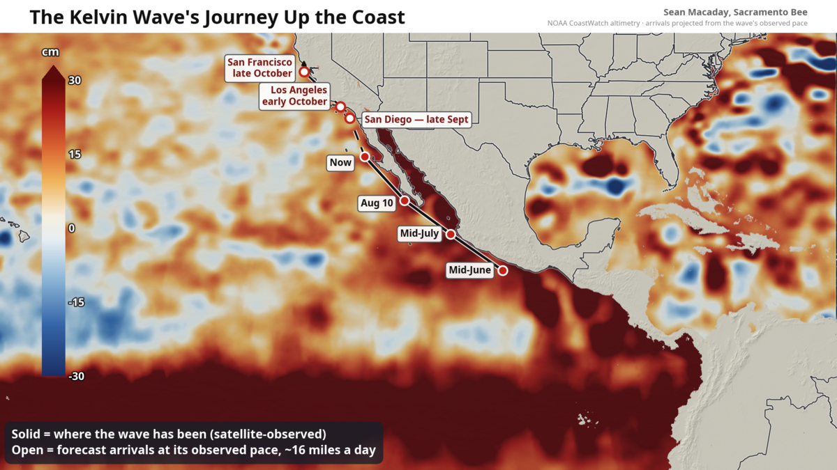
Scientifically classified as a coastally trapped wave, this pulse of warm, elevated ocean water stretches hundreds of miles and is traveling north at roughly 6 mph — approximately the pace of a jogger. As of this week, the wave’s leading edge sits about 300 miles south of Southern California’s beaches, centered off central Baja California.
Origins in the Western Pacific
The wave originated months ago in the far western Pacific, where bursts of westerly wind along the equator shoved a massive pulse of warm water eastward across the ocean basin. When that pulse encountered Central America early this summer, the Earth’s rotation and the coastline’s geometry forced a portion of it to turn left and hug the shore northward, trapped against the coast by the Coriolis effect and the deep pool of warm water accumulated by El Niño.
This is a “downwelling” Kelvin wave: the original warm pulse is so thick that it pushes the thermocline deeper, suppressing the normal upwelling of cold, nutrient-rich water that typically keeps the eastern Pacific cool. Satellite altimetry has tracked its progress continuously — passing Acapulco in mid-June, Puerto Vallarta in mid-July, and the tip of the Baja Peninsula in early August.
Current Conditions and Projected Arrival
Inside the wave, sea levels are running 4 to 8 inches above normal, and water temperatures off Baja have been measured in the mid-80s Fahrenheit. At its current speed, the wave is expected to reach:
- San Diego by late September
- Los Angeles shortly thereafter
- San Francisco around mid- to late October
Coastal Flooding: A Game of Margins
A few inches of additional sea level may sound minor, but coastal flooding operates on margins stacked upon margins. This is not a tsunami; there will be no sudden impact. Instead, the wave quietly raises the baseline upon which daily tides ride for weeks or months.
The effect is most pronounced during peak high tides — typically around full and new moons. With the baseline already elevated, water that would normally stop at the top of the beach can inundate parking lots, bike paths, and low-lying streets. The National Weather Service is expected to issue coastal flood advisories around high-tide windows once the wave settles in. Additionally, any incoming swell will produce larger wave run-up and accelerated beach erosion.
Impacts Extend Inland to the Sacramento–San Joaquin Delta
The connection reaches farther inland than a map suggests. The Delta is tidal, and in early fall — when river flows are near their annual low — the ocean’s twice-daily pulse propagates all the way up the Sacramento River to downtown Sacramento. A higher ocean at the Golden Gate translates into a smaller but measurable lift in water levels through the Delta’s leveed margins upstream. This also shifts the delicate balance between river outflow and salty bay water pushing inland, a critical factor for water quality and ecosystem health.
Record-Breaking Ocean Temperatures and Marine Heatwave
Coastal ocean temperatures will warm rapidly as the wave arrives. The warmest ocean temperatures ever recorded along the California coast are possible for San Diego later this month or in October, running 5 to 10 degrees Celsius (9 to 18 degrees Fahrenheit) above average. For the Central Coast, waters near San Francisco — currently in the 55–60°F range — could warm to near 70°F.
This marine heatwave is expected to be severe, with cascading effects on the marine ecosystem likely persisting into winter. Warmer waters disrupt food webs, stress kelp forests, and can trigger harmful algal blooms.
Compounding Winter Risks: El Niño Rains Meet Elevated Seas
Compounding the threat, seasonal forecasts call for a wetter-than-average winter across California driven by El Niño. Elevated sea levels from the coastally trapped wave will coincide with periods of heavy rainfall and increased river runoff. When boosted high tides push inland simultaneously with storm-driven flows from land, the combined effect could exacerbate flooding in low-lying coastal communities and the Delta region.